
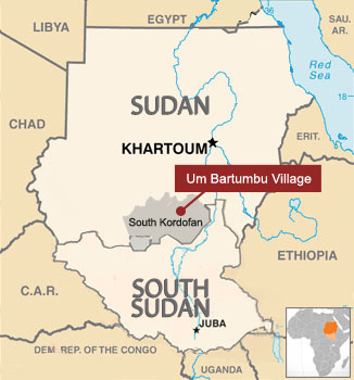
Few have ever heard of the Nuba Mountains village of Um Bartumbu, and fewer still have been there. It is located in the conflict-torn state of South Kordofan, Sudan, where troops fighting for the government of Sudan, and the Sudan People’s Liberation Movement/Army-North, or SPLM/A-N, have been fighting since June 2011. Um Bartumbu Village does not appear on most maps, but it hosts a clinic, a mosque, Sudanese Church of Christ, several storerooms, a communal grinding mill, and copses of desert date trees. But for new eyewitness reports obtained by citizen journalists, the recent discovery and release of a cellphone video, and new confirmation from DigitalGlobe and Landsat satellite imagery, the world would never know of the razing of the village and the forced flight of its inhabitants.
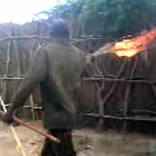
Sometime around March 2012, a SPLA-N soldier found a cellphone video on the dead body of a Sudanese soldier. The undated video shows Sudanese forces dressed like soldiers and Popular Defense Force, or PDF, militia members. They call themselves the “Match Battalion,” and they use torches to raze an unnamed village. Eyes and Ears Nuba, a group of citizen journalists, made the video public on June 12, but the date and location of the video could not be verified.
The Sudanese government denied the razing and claimed that the video was a piece of rebel propaganda. Four days later, Eyes and Ears Nuba, who recognized the village, traveled there on June 16, 2012. They found the village deserted and burned. They interviewed eyewitnesses—a village elder and another former resident—who reported that the Match Battalion had razed and looted the village in late 2011.
They also took photographs embedded with GPS coordinates. The Satellite Sentinel Project, or SSP, a partnership between DigitalGlobe and the Enough Project, used those geo-coordinates to task its eyes in the sky to confirm the village location and solve the mystery of the village razing.
A series of DigitalGlobe images, dating from September 2011 through March 2012, shows the village before and after the razing. (Near infrared technology shows burned civilian structures in black and healthy vegetation in red.) Imagery from November 2011, provided by Landsat 7 (a satellite operated by the United States Geological Survey in a joint initiative with NASA) and confirmed by analysis of additional imagery taken in January 2012 by DigitalGlobe, show that Um Bartumbu village was intentionally destroyed by fire between November 12 and November 28, 2011.
Eyes and Ears Nuba confirmed that the villagers of Um Bartumbu were all Nubans from the Kawalib ethnic group, who voted for the SPLM-N in recent elections. Sudanese government forces have reportedly burned villages populated by supporters of the SPLM-N political party.
Recent photographs, corroborated by eyewitness testimony, show that between March 17, 2012 and June 16, 2012, Sudanese forces returned to remove valuable zinc roofs and metal doors from the Sudanese Church of Christ, the clinic, and three food storerooms.
SSP’s multimedia report, which includes the cellphone video, on-the-ground photographs, eyewitness reports and satellite imagery, is SSP’s first published research on evidence of war crimes since the conclusion of the project’s successful 18-month pilot phase in June. It solves the mystery of the undated cell phone video, contradicts the government of Sudan’s assertion that the razing was faked, and confirms that Um Bartumbu village was intentionally burned in November 2011.
Read the report: “Match Battalion: Confirmation of the Razing of Um Bartumbu Village, South Kordofan, Sudan.”
Photo: A member of the Match Battalion carries a torch though Um Bartumbu village. (Eyes and Ears Nuba)